Canada wildfires July 2026: Maps track fire locations, smoke path, and U.S. air quality in real time
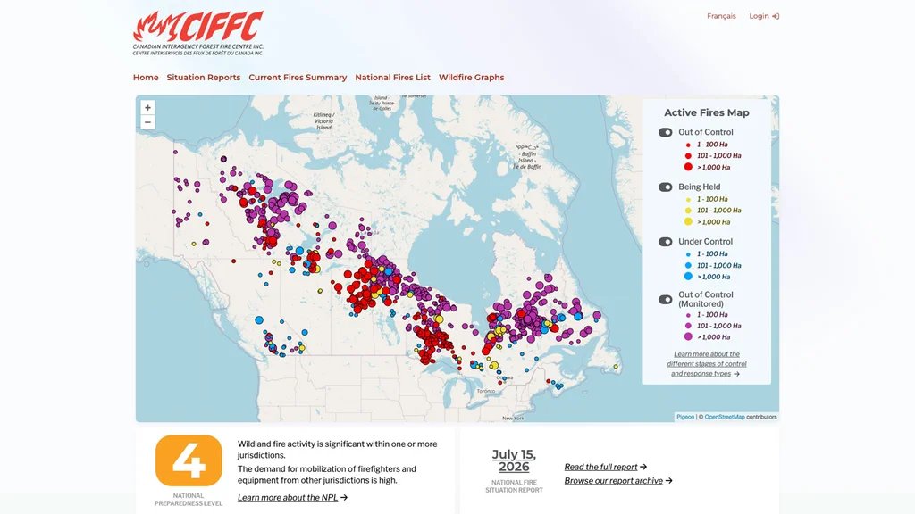
This week, several major wildfires are burning across Canada. Though wildfires are expected as part of an annual cycle, they still pose a threat to animals, people, and property—and air quality.
And it is that last threat that millions of people across America are noticing in recent days. Here’s what you need to know about the July 2026 Canadian wildfires and how their smoke is affecting air quality in the United States.
Canadian wildfire season 2026
Wildfires are a natural part of nature’s cycle, and though they can cause massive devastation, they are also critical to keeping parts of the ecosystem healthy by recycling and dispersing nutrients into the soil and environment.
Of course, this fact is of little comfort to people whose lives are disrupted by the fires. That disruption encompasses threats to life, property damage, and harmful environmental impacts, notably on air quality, which can cause health problems.
And right now is peak season for such disruption, as it is the peak season for Canadian wildfires.
While the Canadian wildfire season generally runs from April to October, the May-to-August timeframe is when wildfires are most abundant—and the disruption and their impact are most severe.
According to data from the Canadian Interagency Forest Fire Centre (CIFFC), as of the time of this writing, there are currently 857 active fires in Canada, with 21 new fires today alone. Of those fires, the vast majority—about 725 of them—are labeled as “out of control”:
- Out of control (Monitored): 534
- Out of control: 191
- Under Control: 89
- Being held: 43
According to the CIFFC, an “Out of control” fire is one in which “the wildfire is burning and is expected to continue growing,” while an “Out of control (Monitored)” fire is one in which “fires with a monitored response type are being observed and assessed, but not immediately suppressed.”
Canada is currently at a National Preparedness Level (NPL) of four, its second-highest designation. A level four designation means, “Wildland fire activity is significant within one or more jurisdictions” and “the demand for mobilization of firefighters and equipment from other jurisdictions is high.”
Canadian wildfire smoke is negatively impacting air quality in the U.S.
While the Canadian wildfires are confined to Canada’s borders, the smoke they produce is drifting into the United States, causing air quality issues across the country.
As noted by CBS News, over the past several days, millions of Americans have been subjected to declining air quality due to the wildfire smoke.
The worst-hit areas are the Midwest and Northeast, where millions of residents are being exposed to potentially dangerous levels of smoke-fueled air particulates.
Declining air quality has led authorities in cities including New York, as well as in entire states including Michigan and Pennsylvania, to issue air quality alerts.
CNN notes that the tiny pollutants in wildfire smoke can enter the bloodstream or lungs when inhaled, which can cause inflammation and breathing problems.
Canadian wildfire 2026 and U.S. air quality maps
There are two good mapping resources to check out if you want to see where the wildfires are occurring in Canada and to monitor the air quality impact in the United States.
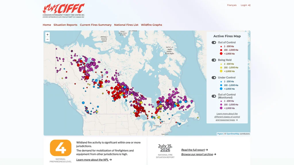
The first is provided by the Canadian Interagency Forest Fire Centre (CIFFC). This map shows where wildfires are currently raging, and color codes them into four groups:
- Under control (blue)
- Being held (yellow)
- Out of Control (Monitored) (purple)
- Out of Control (red)
The wildfires are then further classified by their size, represented by three sizes of dots:
- The smallest diameter dot signifies that the fire stretches from between 1 to 100 hectares
- The medium diameter dot signifies that the fire stretches from between 101 to 1,000 hectares
- The largest diameter dot signifies that the fire stretches for more than 1,000 hectares
According to the map’s data at the time of this writing, the majority of fires classified as “out of control” are spread across Quebec, Ontario, Manitoba, and the Northwest Territories. Quebec is above America’s northeast, and Ontario and Manitoba are above the Midwest.
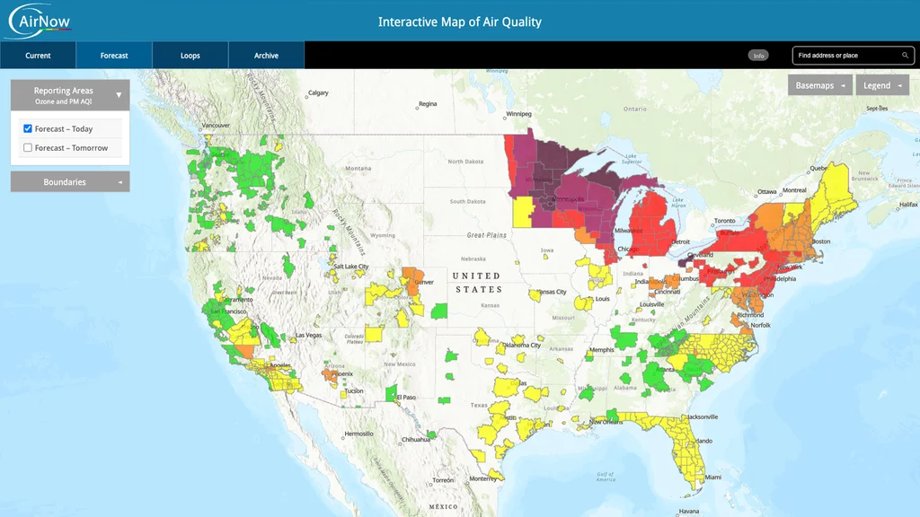
The second map is from AirNow.gov. This map uses air quality data from agencies including the Environmental Protection Agency (EPA), National Oceanic and Atmospheric Administration (NOAA), National Park Service, NASA, and the Centers for Disease Control and Prevention (CDC).
The map shows where air quality is currently most impacted. As of this writing, that includes Minnesota and Wisconsin, each of which has portions of the states under “hazardous” or “very unhealthy” air quality designations.
Michigan and New York aren’t faring much better. Each of those states currently shows “unhealthy” conditions. Meanwhile, states in the upper northeast, including Vermont, New Hampshire, and Maine, show portions of the states with air quality that is “unhealthy for sensitive groups” and “moderate.”
How will U.S. air quality be tomorrow?
According to AirNow.gov’s map forecast, tomorrow the air quality is expected to improve in some of today’s hardest-hit states.
While much of Minnesota’s northern area will still be under a “very unhealthy designation,” other areas of the state, and much of the state of Wisconsin, will see air quality levels improve to “unhealthy” or “unhealthy for sensitive groups” designations.